What Is a Prompt Engineer and How Can You Become an AI Prompt Engineer?
What is an AI Prompt Engineer, what skills are required, and how to enter Prompt Engineering? A complete, practical, and future-oriented guide.
LiDAR or laser distance sensors measure distances and create 3D maps, widely used in autonomous vehicles, robotics, and environmental monitoring.
These sensors calculate the exact distance of objects by emitting laser beams and measuring the time it takes for them to return, helping create accurate 3D models of the surrounding environment.
In autonomous vehicles, LiDAR plays a vital role in detecting surroundings and obstacles, allowing vehicles to optimize their paths and prevent accidents.
Additionally, this technology is crucial in fields such as mapping, precision agriculture, and environmental monitoring, aiding in resource management and analysis.
Recent developments in LiDAR technology include multi-laser systems, artificial intelligence algorithms, and improvements in sensor accuracy and speed, expanding its applications even further.
This article provides a comprehensive overview of LiDAR, its working principles, applications, comparisons with other sensors, and the latest technological advancements.
LiDAR is a technology that uses laser beams to measure distances and model the environment in 3D. It has attracted significant attention in recent years and plays a key role in advancing autonomous vehicles, mapping, and environmental sciences.
With LiDAR, complex environments can be accurately analyzed, providing more precise data compared to other sensors. Its applications are not limited to autonomous vehicles and extend to fields such as agriculture, robotics, traffic management, and even security and surveillance.
This article aims to give you a comprehensive understanding of LiDAR, explain its principles, highlight its advantages and limitations, and introduce the latest technologies and developments in this sensor system. If you want a deeper and practical understanding of LiDAR, keep reading.
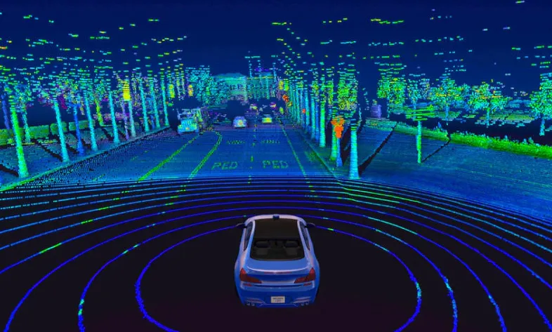
LiDAR is one of the core technologies in autonomous vehicles, helping them recognize their surroundings in 3D. Using these sensors, vehicles can detect obstacles, pedestrians, other vehicles, and objects in their path with high accuracy, allowing for fast and safe responses.
This feature is crucial for reducing accidents and improving safety. Creating 3D maps of the surrounding environment is one of the most important applications of LiDAR, helping autonomous vehicles navigate without human intervention.
Moreover, LiDAR data enables vehicle navigation algorithms to make smarter decisions. It also allows vehicles to handle complex environmental conditions such as night, rain, or fog, while maintaining accurate performance over long distances, enhancing efficiency in both urban and intercity routes.
LiDAR sensors calculate the distance between the sensor and objects by sending laser beams and measuring the time it takes for them to return. This method provides high accuracy and allows for measurement of both short and long distances.
The reflection of laser beams is a fundamental principle of this technology. Another key principle is the use of trigonometry to determine the angular deviation of the laser beams. By combining these methods, the sensor can determine precise coordinates of points in the environment and produce 3D data.
This information is crucial for modeling environments and planning paths for autonomous vehicles. Due to their high accuracy and adaptability to different environmental conditions, LiDAR sensors are widely used in industries such as mapping, architecture, robotics, agriculture, and environmental monitoring. Continuous development enhances their accuracy and speed.
LiDAR technology is based on emitting and receiving laser beams. Sensors measure the time it takes for the laser beam to return and, combined with angular data, create 3D models of the environment. These data have broad applications across industries.
In automotive applications, LiDAR helps autonomous vehicles perceive their surroundings and avoid collisions. LiDAR data enables vehicle control systems to optimize paths and make safe and fast decisions, playing a key role in safety and performance.
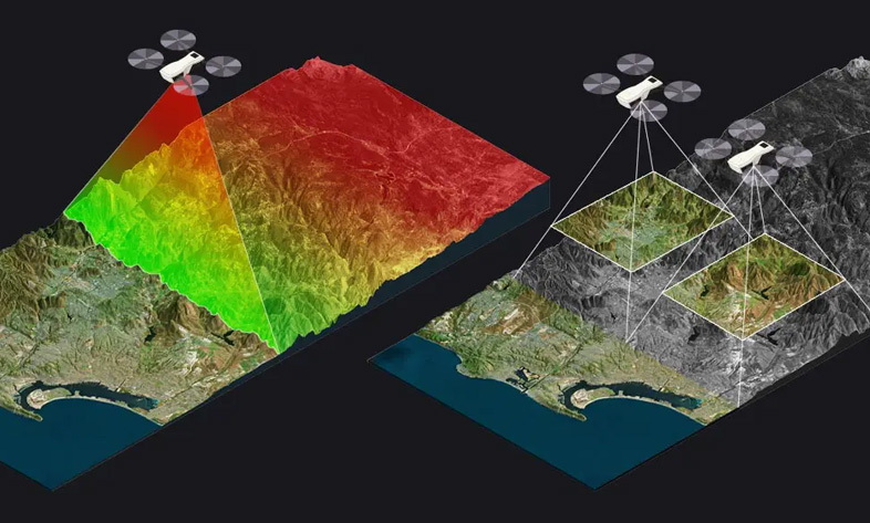
Besides automotive uses, LiDAR is also applied in mapping, environmental management, and precision agriculture. It allows researchers and engineers to create accurate models of land, structures, and natural resources and make better decisions for resource management and environmental protection.
LiDAR offers numerous advantages over other sensors such as ultrasonic or radar. Its high accuracy, ability to measure long distances, and performance in noisy environments make it an ideal choice for autonomous vehicles and drones.
Ultrasonic sensors measure distances using sound waves and can be affected by noisy environments. In contrast, LiDAR uses laser beams, offering higher precision. This makes LiDAR especially valuable in applications requiring high accuracy.
Moreover, LiDAR can generate 3D data and create precise environmental maps, while many other sensors only provide 2D distance measurements. This makes LiDAR highly suitable for applications that require detailed environmental awareness, including advanced autonomous driving and mapping.
LiDAR technology continues to evolve, incorporating multi-laser sensors, improved accuracy and speed, and artificial intelligence algorithms for data analysis. These advancements expand its applications and overcome previous limitations.
Multi-laser systems enable longer and more precise distance measurements, which are critical for autonomous vehicles, drones, and mapping projects. Additionally, AI-powered data processing allows faster and more accurate object recognition.
Other improvements include faster sampling rates and reduced production costs, making LiDAR more cost-effective and efficient across industries. Overall, the development of LiDAR promises a bright future with wider practical applications for these sensors.
What is LiDAR and how does it work?
LiDAR is a laser sensor technology that emits laser beams and measures the time it takes for them to return, determining the distance and position of objects while creating 3D environmental maps.
What are the main applications of LiDAR in autonomous vehicles?
LiDAR helps autonomous vehicles detect their surroundings, identify obstacles and other vehicles, and optimize navigation to enhance safety and performance.
How does LiDAR differ from other distance sensors?
LiDAR offers high accuracy, long-range performance, and 3D mapping capabilities, while ultrasonic and radar sensors generally have limitations in precision and range.
What is the future of LiDAR technology?
With advancements like multi-laser systems, artificial intelligence algorithms, and improved accuracy and speed, LiDAR applications in automotive, mapping, and other industries will continue to expand.
Source » Itroz Academy


What is Generative AI? A Simple and Complete Guide: From AI Basics to Architectures, Examples, Risks, and Applications — For Readers with No Prior Knowledge.

What AI models does a physical humanoid robot need? From perception and vision to decision-making, motion control, memory, and safety considerations.


Follow the guide to set up your domain email on any device or OS, including both smartphones and computers, quickly and easily.

This guide is useful for automatically forwarding your website emails set up on your domain to other email accounts, such as Gmail and others.

Step-by-step guide to install Thunderbird on macOS; download, setup, and manage multiple email accounts easily and efficiently.

Comments (0)